Sela’an Linau Forest Management Unit, Upper Baram, Sarawak, Borneo

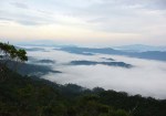
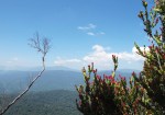
Misty mountains of the Sela’an Linau Forest Management Unit (FMU), Upper Baram, Sarawak, Borneo
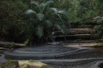
The Sela’an Linau Forest Management Unit (FMU) covers 55,949 hectares (or roughly 559 km2) and lies in the hinterland of northern Borneo, north of the upper Baram River in the Malaysian state of Sarawak. Samling is the licensed concessionaire. In the FMU live many indigenous peoples such as the Kayan, Kelabit, Kenyah and Penan, many of whom depend on forest for their livelihood and on wildlife for their protein.
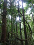
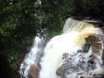
The Sela’an Linau FMU is undulating in nature, with altitudes ranging from 300 m above sea level (a.s.l.) in its south-west to about 2000 m a.s.l. in the Tama Abu Range on its eastern edge. Almost 60% of the FMU supports mixed dipterocarp forest, with some montane forest on higher ground (4%) and tropical heath forest (kerangas) on infertile soils (21%). Old and current slash and burn areas (temuda) of native communities cover the remaining 15%. Enrichment planting with native timber species is being done in some 3000 hectares that burnt during the 1997 – 1998 El Niño event. About half the forest was conventionally logged in the past but since 2003, a reduced impact logging (RIL) is applied. The area receives high rainfall (3,400 – 5,900mm annually) with no distinct wet or dry season. Temperatures in low-lying areas average around 26˚C, falling to 14˚C on summits.

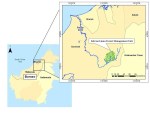
Map of the Selaan-Linau FMU in the Upper Baram


All images © HOSCAP Borneo